| DIY speakers amplifiers design loudspeaker design amplifier DIY DIY DIY super high quality real Hi-Fi studio quality home studio recording engineer enjoy feast revel audiophile extra natural sound detailed open unmasked perfect sound music lover lovers studio monitors home cinema entertainments | ||
|
>30 free navigation apps in more challanging tests than usual. After three whole days of testing (puh!), one stood out from the rest. Android iOS iPhone pad tablet phone navigator navigation app GPS satnav sattelite maps software free totally best no in app purchases no ads detailed maps automatic change from car to pedestrian bike bus tram train ferry walking foot roads lanes public transport quick swift calculation midpoints altitude TomTom Tom Tom OSM OpenStreetMap Open Street Map Google Maps comparison 15 20 25 30 challenging tests review
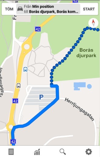
We have read a lot of "Top 10 (or another number) free offline navigation apps" and similarly named sites. The problem is that almost none of them contains any really challenging tests. You are told what the apps can do, but not how well they do it. Like this: You can insert waypoints... Fine, but does it take eight seconds or two minutes to calculate the new route? You can get navigation to our shop... but do you have to input the address, or can you just input "Valutronic"? The app can quickly calculate the way to a restaurant nearby, but what planning a >1000 km vacation trip? Can it distinguish between car roads and bike- or foot paths? Does it even find foot path through a park, or will it guide you around the park via the surrouning roads / sidewalks? The answers are important to me and my wife, we usenavigation often. But we did not find the answers in any test we read, so I decided to test more than 30 "free" "offline" navigation apps myself. Apps with high scores in both online tests and by users on Google Play. We already had a totally free of charge (and free of ads as well) navigation app called Offline Maps & Navigation. When it suddenly disappeared from Google Play i got worried: Maybe it was an illegal rip-off? It was suspiciously close to the Sygic Navigation app. And if not, it it disappears, so will the map updates. But why not simply use Google Maps, the "standard" Android app? someone may ask. 1. It is primarily an online navigator, and we want offline navigation. We have limited data per month on our phone, and use navigation a lot, so online navigation is not an option. 2. The app is seriously crippled offline. You can download and install maps for offline use, but not even a small country like Denmark will fit the limited memory space. We want offline navigation to work in both Sweden, Denmark, Germany and the Netherlands when we are on vacation. 3. Spyware! A normal install of Google Maps will collect info and low almost everything you do. Where you are, what you search for, where you go, for how long... The data is transmitted to Google. And they can sell your info to a third party. Maps does NOT honor your privacy. You can try to opt-out these functions, but it is a complicated process, and tests indicate that you still send info too Google. This is of course part of their business plan: Give away an app "for free", collect data from the user, and sell it to a third party (who knows who). Unfortunately Google Maps was impossible to uninstall, but at least we could deactivate it. So... we tested over 30 of the most popular (most stars) "free offline navigation apps" on Google Play. We really wanted to find out which app was the best, so we downloaded them all, and set up two tests: 1. Navigation to Borås djurpark (a rather large open zoo, a popular tourist attraction in western Sweden), just inputting the name, not any address. This way the destination will be inside the zoo, where you cannot go by car. So, where will the apps take the car? Will they find the foot path that leads via the entrance into the zoo? 2. Navigation to a very far place. We start in Gothenburg Sweden, and go by car to Noord Holland in the Netherlands, to a small camping where we use to spend our summer vacations. We need to add three waypoints, so it follows our favourite route. Via the Helsingborg-Helsingör ferry to Denmark, not the Öresund bridge. Then via the bridge over Storebaelt instead of the ferry Rödby-Puttgarden, and finally from north via Afsluitdijk to the camping instead of from south via Amsterdam. Total driving distance 1250 km one way. First, let´s see how a few apps handled the "zoo test". I have selected three apps here, showing three problems: 1, Google Maps 2. Offline Maps & Navigation 3. Maps Me 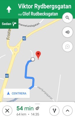 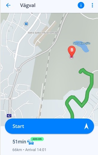 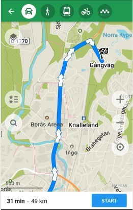 1) Google Maps. As you can see, very few details. It drives past the parking place and continues on a road west of the zoo until it is as close to the destination as possible (birds view). But there is no parking place there, and it is far from the entrance to the zoo. You have to turn back to the parking place, park the car and find the entrance yourself. 2) Offline Maps & Navigation also passes a parking place, and continues a bit into the zoo itself on foot paths. Forbidden, of course, and you will have to drive through a steel fence... 3) Maps Me is a Google Play "editors choice". Well, maybe the editors drive tanks, because that is what you need! It (like Maps) drives to the west of the park, and when it is close to the destination it simply leaves the road and goes through the terrain over fences, bushes, trees... all the way into the zoo. Of course you don´t do this with a car, so you have to turn back to the parking place and find the entrance yourself, just like with Google Maps. 4) Magic Earth. Did we forget the map image for this one? No, it is the first map on this page (scroll up). Notice how perfect this app works: First it uses car navigation (solid blue line) to the parking place. Then it automatically switches to foot navigation (dotted blue line) via the entrance and into the park, following the foot lanes in the zoo. Perfect! This is not a unique situation. There are many places where you cannot drive a car. For example a park, a recreation area, a beach or other areas only accessable by foot or bike. Congratulation to the developers of Magic Earth, well done! Now, the next test: Plotting the quickest route from our shop i Gothenburg to a small camping in Noord Holland in the Netherlands. Then inserting three personal waypoints, and measuring the time needed for this. The phone used was a Leagoo M8 Pro smartphone with Android 6.0 and MT6737 SoC. A "typical 100 USD smartphone" from 2017. It may be quicker with more modern devices and slower on older gear, but I don´t know how much. Let´s compare Maps Me (Google Play "Editor´s Choice") to Magic Earth: Input the name of the camping, choose it from the list and ask for navigation by car. Time until the recommended route was ready: (Well, three alternative routes on Magic Earth) Maps Me: 1½ minute. Magic Earth: 8 seconds. Re-routing after inserting the three waypoints one-by-one: Maps Me: Between 1 min 40 seconds and almost 2 minutes each time. Magic Earth: 8 seconds each time. I think this speaks for itself. Total calculation time 7 minutes compared to a little over half a minute. Maps Me may be OK for short distances, but mapping a longer vacation trip can be tedious. Some other apps were even slower than Maps Me, one app refused to calculate this trip at all, claiming it was "too long". So, Maps Me was not the worst case, I only chose it for this comparison because it was the "Editor´s Choice" and I therefore expected it to be better than this. Magic Earth was the speediest of them all, closely followed by Offline Maps & Navigation that needed 10-12 seconds for each task. There were also a few others that had acceptable speed (less than 30 seconds for each task), but... Then I wrote down features that I really want in a navigation app, to see if any of the "acceptable" apps would fill my needs. I think you would want most of these things to: 1. Navigation offline with pre-installed maps on the SD card, not the internal memory as it is quite limited. (We have limited cellphone data , and we don´t want to spend it on navigation.) 2. Navigation online when we want to, for example to get updated traffic information. 3. Voice navigation, turn-by-turn. Watching a map while driving a car or bike is dangerous. 4. Bluetooth (telephone call type, so we can listen to music and radio only interrupted by navigation instructions and telephone calls). 5. Quickly calculating and plotting long routes through several countries, preferably with alternative routes. 6. Quick re-routing when we deviate from the recommended route. 7. Really free, not a "crippled" variant that needs in-app purchases to become complete. 8. Preferrably completely without ads, and absolutely not popping up ads during driving. 9. Navigation for car, bike, on foot. And, if possible, also public transportation. All in one app. 10. No spyware. No data collected and delivered to the developers. They must respect my integrity. Of all tested apps only one (1) ticked all the boxes: Magic Earth. All the others failed on at least one important point in the list, most of them on several points. So, Magic Earth succeedes in both my demanding tests, and ticked all the boxes in my want-list. The use of OpenStreetMaps is a good choice these days. Just a few years ago they were very primitive, a lot of roads and buildings were not mapped, but things have changed. Over half a billion (500 000 000) streets, car roads, bike- and footpaths are mapped, and the number of POI:s is huge. And if you lack something, you are free to join the community and make adjustments. They will be checked, and then your changes will take place. I personally added my company (Valutronic) so you don´t need to know the address to navigate here using Magic Earth. I also added a streetname in june 2019 and in july 2019 when Magic Earth updated the maps it was there. Not just in my phone, but in every navigation app using updated OSM maps of south-west Sweden of a Gothenburg city map. All in all -- After extensive testing I find (and this is of course my personal opinion) Magic Earth to be an outstanding navigation app that I can recommend to all my friends (and all others who read this). It is completely free, so you have nothing to loose by testing it. Play around with it for a while to get aquainted with how it works and I am convinced you will like (if not love) it. Maybe you have an old and tired Android phone or tablet? Don´t worry, we have tested Magic Earth on an old dual core phone with Android 4.2.2 and it worked perfectly. However, on iOS it is not the same. When trying to install it on a friends iPad with iOS X (10) a sign came up telling us to upgrade the iOS to a later version before installing. The only app except Magic Earth that I would consider to use myself is Offline Maps & Navigation. But... was that not an illegal clone of the Sygic navigation app? Well, first I thought so, but after digging a bit deeper I found this: https://gps-navigation-maps.com/eula It is the "SYGIC END USER LICENSE AGREEMENT" where you can see a list of apps who are licensed by Sygic, and Offline Maps & Navigation is one of them! So it is not an illegal clone after all, and when this was written (July 2019) it was back on Google Play. So, for the conclution: Number 1. Magic Earth. The overall best free offline navigation app I have ever tested so far. It is really good, it is really free, it is ad free, and it respects your privacy. Navigation for car, bicycle, pedestrian and public transport (bus, tram, subway, train and ferry) in areas where local traffic companies supply that information. You can download all the maps you need in advance (if your phone/tablet has enough free memory). Maps are stored primarily on your SD card, but if it is full they automatically are stored in the internal memory instead. Or vice versa, it is your choice. You can insert as many waypoints as you want to if you are not satisfied with any of the (often three) routes the navigator suggests. No ads. Ads popping up in a difficult traffic situation could be really dangerous. HUD (head up display) if you want it when driving at night. Both male and female (!) recorded voices in more than 50 languages plus of course, text-to-speech in all languages covered by your mobile unit*. By choosing to play voice as phone call via Bluetooth, the app automatically switches from the phone speaker to the bluetooth unit (earphone, speaker, car stereo...) when connected, and back to the phone speaker when the other device is turned off (or Bluetooth is disabled on either device). Speed limit warning. You can set the tolerance yourself from -20 to + 20 km/h in both urban and rural areas. Speed camera warning. In countries where this is forbidden, you can uninstall speed cameras from your maps. Warnings timing can be set to early, normal and late (or off). You can set map navigation to 2D, 3D and automatic. In automatic it is 3D while driving normally, but when you get close to a point where you can choose betweens lanes or are supposed to change direction, it automatically changes from 3D to 2D and zooms in to give you a clear view of what to do. Lane assistance. When there are several lanes it indicates what lane (s) to choose. You can choose when to autostart your navigation after inputting your requests: Off, 10 seconds or when moving. Demo mode (you choose starting point and destination, then you can "test drive" the route). Adjustable speed from 1 x to 10 x normal speed (determined by "normal" speed on your route. Because although there might be a 50 km/h speed limit, circumstances like bad road quality, school crossings et.c. will make you drive slower, and the demo mode takes these things into consideration. Route profile. In bicycle mode you can view a graph of the altitude from start to stop. As you usually get three alternative roads, you can choose the one that demands the least "mountin climbing" if you want to. Map data cache size is settable. When you don´t use offline maps and you have an internet connection, local maps will be downloaded and used (like Google Maps). However, not to fill up your phone memory or SD card, you can limit the maximum memory uset between 300 MB and 3 GB. You also have a choice of map settings: Map layers: Traffic (online), 3D buildings, weather, Speed cameras, Wikipedia (online) and your favourites. Map styles: Standard, Satellite (online), terrain and terrain + satellite (online). Points of interest: Petrol stations, parking, food and drink, doctors, companies, car repair, schools, amusement, geographical area, public services, transport, religious places, along the road, sightseeing, sport and uncategorized. This is what I have found and adjusted to my needs, but of course you can just use the default settings if you feel uncomfortable to change any settings. They are pretty OK. Sounds advanced and maybe difficult? Not at all! Just play around with the app until you get to know it. Then you will probably love it. Magic Earth is available on both Google Play and App Store. You might ask yourself... How can it be free and not even have ads to pay for it? The company (General Magic) makes money selling "Safety lens", and advanced Driver Assistance System for iPhone. Magic Earth is part of it, but as a separate app it is given away for free. So, thanks to all who buy Safety lens! Magic Earth´s official site with more info about the app: Click here. *) Using text-to-speech (a synthesized voice, but usually very clear and understanable these days) you get more info than with the recorded voices. For example a recorded voice might say "turn left at the next intersection" while the text-to-speach voice may say "turn left at the next intersection onto Drunken Hillbilly Road, following the signs towards New York." That is because you cannot make audio recordings of every place and road on the map, it would take forever. But the names are on the map, so the text-to-voice engine fixes the issue. Number 2. Offline Maps & Navigation. It uses TomTom maps, so at least when navigating your car to a street address where you can park your car it will get you there. Sygic is considered one of the best navigation apps using TomTom maps, and Offline Maps & Navigation is almost an identical clone, except it is free of charge. The only difference I have found is that Offline Maps & Navigation lacks traffic info, but that is something you can add if you pay for it. However... the app nowadays asks for permission to personalize ads, which makes me wonder. I have not seen any ads using Offline Maps & Navigation, so it seemes they inform others (who show ads) about your driving habits, unless you opt-out from this. (And maybe also if you do, I don´t know.) Apart from this, it is a good, solid car navigation app, even if minor companies and restaurants are missing from the maps and it lacks dedicated foot lanes through parks and other areas where there are nog car roads. Number 3 and onwards -- No deal. As long as Magic Earth exists and works on my phone, why should I either pay for something that is not better, or accept irritating ads or try to do with less functions? Apart for Google Maps, Offline Maps & Navigation, Maps Me and Magic Earth, we also tested the apps below. Some names are in Swedish because it is the system language of our phone. I suppose those names are in the language of your mobile device instead. (You can always try Google Translate...) Sygic GPS Navigation & Maps MapFactor GPS Navigation Maps Free GPS Navigation: Offline Maps and Directions Offline GPS Offline Map Navigation HERE WeGo – Stadsnavigering off-line navigering körning & GPS rutt Kartor Offline Maps: Kör och navigera med GPS-kartor Maps (Google) TomTom GPS Navigation - Trafik och Fartkameror Offline Maps, GPS, Körbeskrivning OsmAnd — Offline resekartor och navigering Locus Map Free - Outdoor GPS navigation and maps Offline gps - Kartor Navigation & Vägbeskrivning Navigation & Maps : shortcut Offline Maps & GPS Navigation Offline Maps & Navigation : GPS Route Finde Offline Maps,Navigation,Vägbeskrivning och Traffic GPS Navigator with Offline Maps Waze - GPS, kartor och trafik Voice GPS Driving Directions - GPS Navigation GPS Map Navigation plus Direction Finder Offline. Offline Maps & Voice Navigation:GPS Route Finder röst GPS navigator levande trafik transit kartor Live GPS-navigering: offline-kartor och navigering Navmii GPS World (Navfree) GPS-navigeringskartor Offline Maps and GPS Offline - Car Navigation There were also a few others whose names I have forgotten. /Stefan Berge, Valturonic, Gothenburg, Sweden. Page made on 21-22 july 2019 |
||